Vancouver / UBC
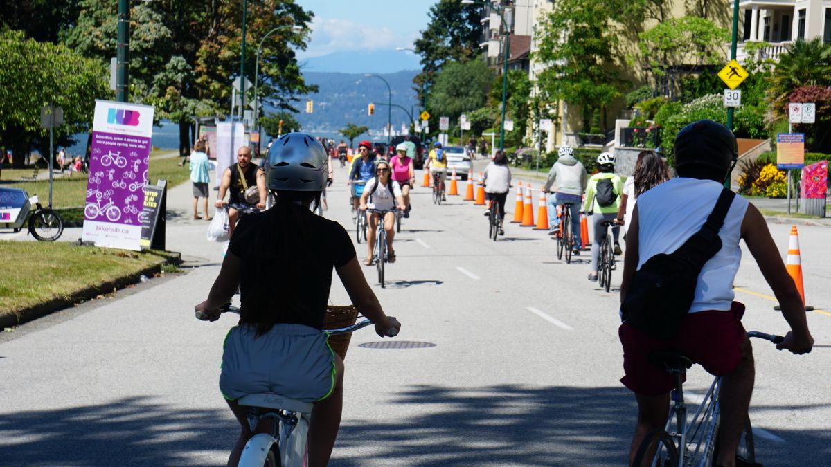
Ride your bike in Vancouver or UBC/University Endowment Lands? Interested in local cycling advocacy, education, or events? Attend the next Vancouver/UBC Local Committee meeting to see what's happening. We're always looking for new members. All are welcome - no experience required!
Email Jeff Leigh & Anthony Floyd, the co-chairs of the Vancouver-UBC Committee, to find out more about the committee.
Join our mailing list via groups.io to get regular updates, follow the public discussion about cycling in Vancouver and UBC, and to receive meeting announcements and links.
You can also follow us on Mastodon @HUBVancouverUBC@mstdn.ca or Bluesky @HUBVancouverUBC.bsky.social
HUB Cycling views the diversity of our members and communities as assets and strive to create and sustain a diverse and culturally competent organization that reflects the populations we serve. This is central to our mission, “to get more people cycling more often” and to our ongoing efforts to remove barriers to cycling.
COMMITTEE INFORMATION
Co-chairs: Jeff Leigh and Anthony Floyd
E-mail: vancouver@bikehub.ca
Join the mailing list: hubcycling.groups.io
Visit wiki.bikehub.ca to access past committee meeting minutes, communications, ride assessments, and more.
MEETING INFORMATION
The Vancouver Local Committee has been meeting virtually due to Covid-19. Contact vancouver@bikehub.ca to be added to the mailing list and receive meeting announcements, agendas, and meeting links.
Monthly on 3rd Tuesday, 6:30-8:30 pm (No meetings in August and December)
Location: Online, via Zoom, or Hybrid (In-person + Zoom)
Local Committee Guiding Principles
Choice of Infrastructure
Prioritize separated lanes and phase-separated signals over painted markings to assure safety and comfort for people on bikes.
“Paint is not infrastructure”
Choice of location
Prefer areas where people frequently travel, such as commercial high streets, transit nodes, work centers, cross-town routes connecting these destinations, interregional routes, and other desirable destinations.
“Put infrastructure where people want to go”
Choice of route
Cycle routes that are winding and indirect have been shown to discourage cycling and can compromise safety.
“Prioritize direct routes for people on bikes, instead of unnecessarily winding paths”
Help for the vulnerable
Focus on infrastructure that encourages the use of bicycles by vulnerable and equity-deserving riders, and develop safe bypass routes for fast and confident riders.
“New improvements should appeal to people new to cycling, not just avid cyclists”
Infrastructure for parks
Advocate for safe and accessible cycling routes, not just to parks but also inside parks. People on bikes are park users.
“To and through parks”
Infrastructure for schools
Advocate for School Streets that provide a car-free block beside every school in Vancouver so that children and their parents can walk, bike, and roll to school during pick-up and drop-off.
“Safe schools for all children”
Equitable advocacy
Consider the diverse needs of individuals and devices, including all ages and abilities, genders, children and families, incomes, backgrounds, people new and experienced in cycling, older people, people cycling with disabilities, and all types of bicycles including e-bikes, cargo bikes, recumbent bikes, hand-bikes, and other useful inventions.
“Equitable advocacy helps everyone”
Fresh ideas
Promote novel ideas like school streets, cycle-permeable parklets and plazas, and car-free blocks to encourage safe and comfortable cycling throughout the city.
“Roads are for people, not cars”
AAA cycling network
Encourage expansion of the AAA cycling network beyond Downtown and the Broadway Corridor, with a specific focus on underdeveloped areas on the south and east sides of the city, and connections to cycle networks in neighbouring municipalities.
“There is more to Vancouver than downtown” “There is more to a city than its downtown”
Speed limits
To enhance safety, lobby for a maximum speed limit of 30 km/h in areas where people driving and cycling share space. At 50 km/h, 80% of pedestrians will die in a collision. At 30 km/h, 85% of pedestrians survive a collision.
“Speeding vehicles endanger people on bicycles”
Bike crashes
Use the term “crash” to emphasize that most accidents are preventable, and call for engineering solutions to reduce them.
“Crash, not accident”
Respect
Practice constructive collaboration with staff and elected officials to achieve long-term goals and maintain respectful and nurturing relationships.
“Work with politicians and staff, not against them”
Theft
Push for safe and secure bicycle parking and end-of-trip facilities. They play a critical role in encouraging more people to cycle regularly. People will choose not to cycle if there is a risk their bike will not be there when they return.
“Bike thieves are everywhere”
Social Rides

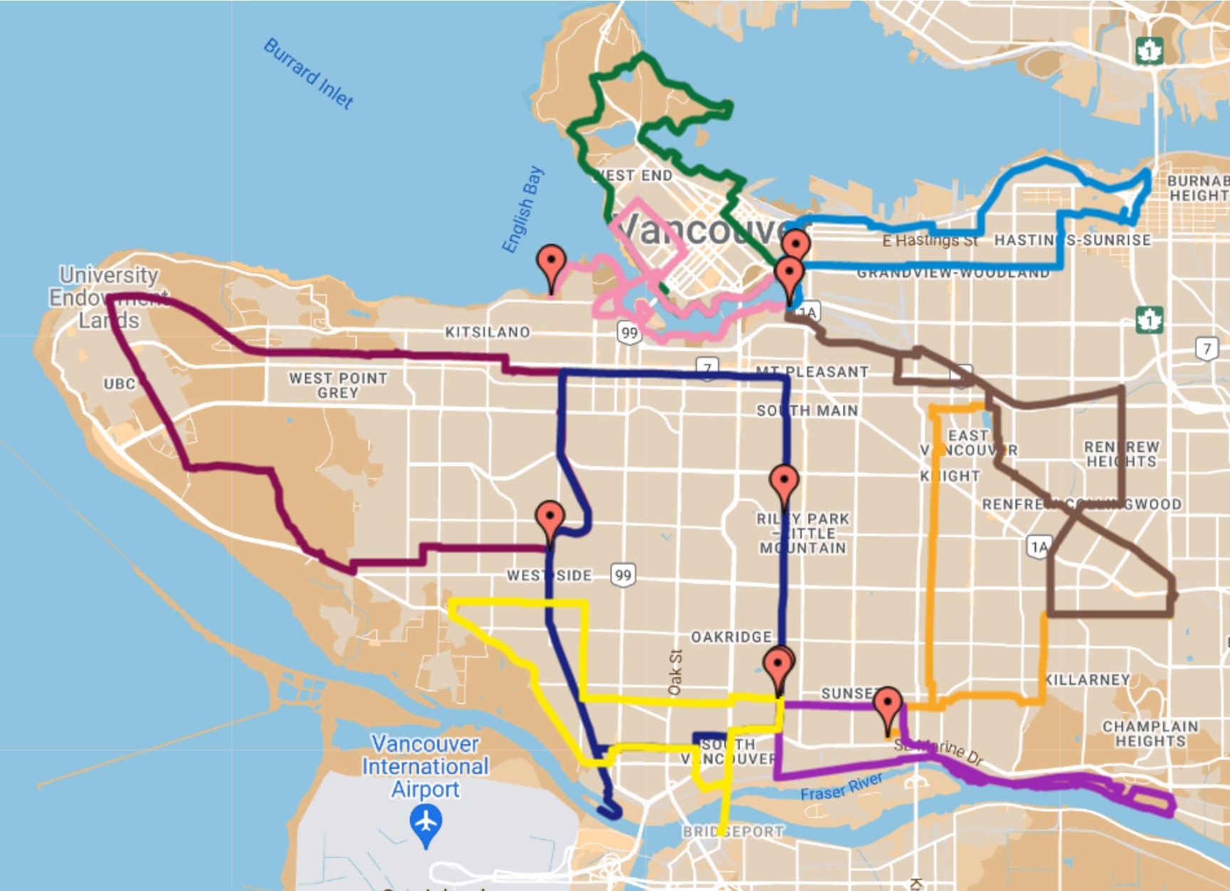
The Local Committee has been going out for social rides for most of 2023. These rides occur at a "social pace", which turns out to be about an average of 15 km/h. The rides are loops, with starting points throughout the city. The rides are intended for socialization, but also to show committee members cycling routes and infrastructure in parts of the city they might not be familiar with. In the summer, the rides occur on Tuesdays opposite the LC meetings, and in the winter the rides occur on Sunday afternoons to take advantage of daylight. Ride dates, routes, and sign up links are posted to our groups.io a week or more before the ride date.
Current Projects
Working Groups
- Cycling in Parks: Working to improve cycling in Vancouver parks, including Stanley Park, the Seaside Greenway and the Kits Beach area for all users.
- Arbutus Greenway: Monitoring progress and providing feedback on improvements to the Arbutus Greenway
- Broadway Subway: Planning for mitigations during construction, and safe access to all future subway stations for people using all modes, as well as making Broadway a more complete street following subway construction
- Assessment Rides and/or media events to highlight infrastructure issues and present recommendations on required improvements (periodic)
- Elections: Monitoring City Council and Park Board issues and voting records, as well as comparing party platforms to votes and public statements for holding politicians accountable, and in preparation of the next municipal election (October 2026)
Other projects
- Monitoring all City projects relating to improved cycling infrastructure, preparing position papers and recommendations, and participating in the City of Vancouver public engagements/consultations on these projects
To see the Vancouver-UBC Local Committee's 2023 Action Plan, click here.
Infrastructure Improvement Priorities
The Vancouver UBC Local Committee works to prioritize cycling infrastructure issues throughout the city. Improvement opportunities are prioritized with the aim of creating more “Safe Routes to Places That Matter.” We consider utility, safety, and feasibility in our evaluations. Our aim is to get more people riding, more often, so we look for opportunities that will have the largest impact. A map of all City of Vancouver and UBC Cycling infrastructure, as assessed by the HUB Cycling State of Cycling benchmarking project, as well as our identified cycling network gaps, can be found here.
The following are a selection of our top priorities for 2023:
- Stanley Park cycling routes, including a protected lane around the park
- The Portside Greenway along the Powell Corridor from Gastown to the Iron Workers Memorial Bridge
- Kent Avenue from Boundary Rd to connect to the Arbutus Greenway
- The Pender Corridor, from the Dunsmuir separated cycling lane at Hornby through to the Stanley Park causeway paths (our recommended connection is along Hastings from Burrard to Cardero)
- The Adanac Bikeway, from Main St to Boundary Road, with a focus on the eastern end and the Adanac overpass at Cassiar
- The Stanley Park Causeway connections at the southern end of the causeway
- NE False Creek, including Pacific Blvd, Expo Blvd, the Georgia Ramp, Quebec St, improvements on Prior, and the new Dunsmuir Connector for active transportation, all related to the removal of the viaducts
- The Gastown Complete Streets project, including Water Street
- Ongoing improvements along 10th Avenue from Trafalgar Street to Victoria Drive
Successes
- Parking meter to bike rack conversion (2023)
- Central Valley Greenway Improvements (Clark to Victoria) (2023)
- Grandview/Woodlands Neighbourhood Calming (2022)
- Kits Beach Seaside Greenway protected cycle path (2022)
- Granville Connector, Phase 1 (2021)
- Smithe Street Bikeway (2021)
- The Beach Avenue Bikeway from Hornby to Park Drive (temporary improvements, followed by interim upgrades) (2020)
- Richards St Bikeway (Cordova Street to Pacific Blvd, first phase completed in 2020)
- Ontario Greeenway Improvements (5th/7th, 16th) (2020)
- Quebec St (1st-5th) (2020)
- 10th Avenue street improvements from Oak Street to Willow Street (phase 1 of the health precinct) (2019)
- Interim improvements along 10th Avenue near Arbutus Street between Maple Street and Vine Street (2019)
- Powell Street bypass extended to MacLean Drive including bike activated crossing signal light (2019)
- Multiple improvements along Alexander Street bikeway including protected bike lane to connect with Powell Street Overpass and crossing improvements at Maple Tree Square (2019)
- Bicycle lanes painted on the previously repaved NW Marine Drive from W 4th Ave to Spanish Banks concession (2019)
- Further extensions along Pacific Street from the Burrard Bridge (eastbound) near Vancouver House (2019)
- Painted bicycle lanes added on Rupert St from the Central Valley Greenway to 14th Avenue (2018)
- Southbound protected bike lane on Cambie Bridge (2018)
- 67th Avenue connector from the Arbutus Greenway to Heather St (2018)
- Alder Street connector between 7th Ave and 14th Ave (2018)
- 1st Avenue upgrades from Ontario St to Quebec St (2018)
- The protected intersection at Pacific and Burrard (2018)
- Improvements to 10th Avenue including protected bike lanes from Oak Street to Willow Street and traffic diversion from Willow St to Cambie Street (2018)
- Upgrade to a protected bike lane along the South False Creek Seaside Greenway from Cambie to Granville Island (2018)
- Completion of the Burrard improvements from Burnaby St. to the bridge, the bridge deck itself, and Cornwall to 8th, as well as intersection improvements at Pacific and improvements along Pacific from Howe to Burrard. (2017)
- Improvements to the False Creek Seawall route from the Cambie Bridge to 1st Ave, including separation of people walking and people on bikes (2017)
- Traffic calming along Charleson to improve the Seaside Bypass route in South False Creek (2017)
- Completion of the Temporary Paved Path on the new Arbutus Greenway (2017)
- Completion of Phase 2 improvements to the Seaside Greenway along Point Grey Road (2017)
- Traffic calming along 7th Ave at Oak St (2017)
- Improvements to SW Marine Drive cycling infrastructure, from Granville to Camosun (2017)
- Improvements to bike lane access at the intersection of Knight at SE Marine (2017)
- Assessment Ride Reports completed for multiple routes, for both new projects and post-construction follow-up (2017)
- Implementation of downtown protected lanes on Nelson, Smithe, Beatty, and Cambie (2016)
- Start of construction on the new Arbutus Greenway (2016)
- Spot Improvements throughout the City (2016)
- Assessment Ride Reports completed for multiple routes, for both new projects and post-construction follow-up (2016)
- Improvements for cycling on the Stanley Park Causeway (2015)
- Spot improvements throughout the City (2015)
- Implementation of the Point Grey Rd - Cornwall Ave Seaside Greenway - (2014)
- Implementation of the Comox/Helmcken Greenway (2014)
- Spot Improvements throughout the City (2014)
- Created a Spot Improvement priority list for the City of Vancouver (2014)
- Opening of the widened path on the Ironworkers Memorial Bridge (2014)
- Approval of the Point Grey-Burrard section of the Seaside Greenway (2013)
- Commitment from Province to widen the cycling pathway on the Ironworkers Memorial Bridge and to improve safety on the Stanley Park Causeway (2013)
- Approval of cycling improvements to the north end of the Cambie Bridge, connections to the Canada Line Bridge, and Union-Adanac bikeway selected improvements (2013)
- Provided feedback to the Cycling Master Plan for Stanley Park (2012)
- Contributed to the City of Vancouver Transportation 2040 Plan (approved by council October 2012)
- Permanent separated bike lanes on Burrard Bridge, Hornby, and Dunsmuir Streets downtown (2009-2012)
- Repaving of residential bike routes, the addition of crossing signals and bike boxes at busy intersections (2011-2012)
- Bike bridge over the Fraser River between Vancouver and Richmond following the Canada Line (2009)
- Bike lanes throughout Vancouver's downtown core (2002–2006) separated lane trials (2010)
- Wider sidewalks for cyclists on the Lions Gate Bridge (2001)
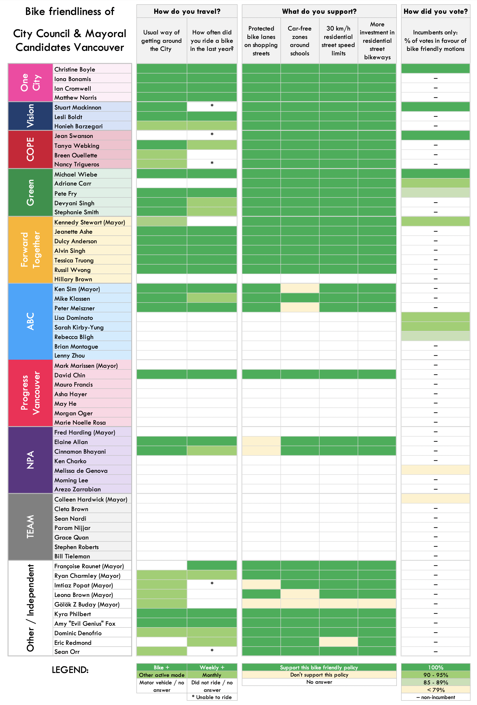
2022 Municipal Election Survey
Survey Results
Mayor & Council
Parks Board
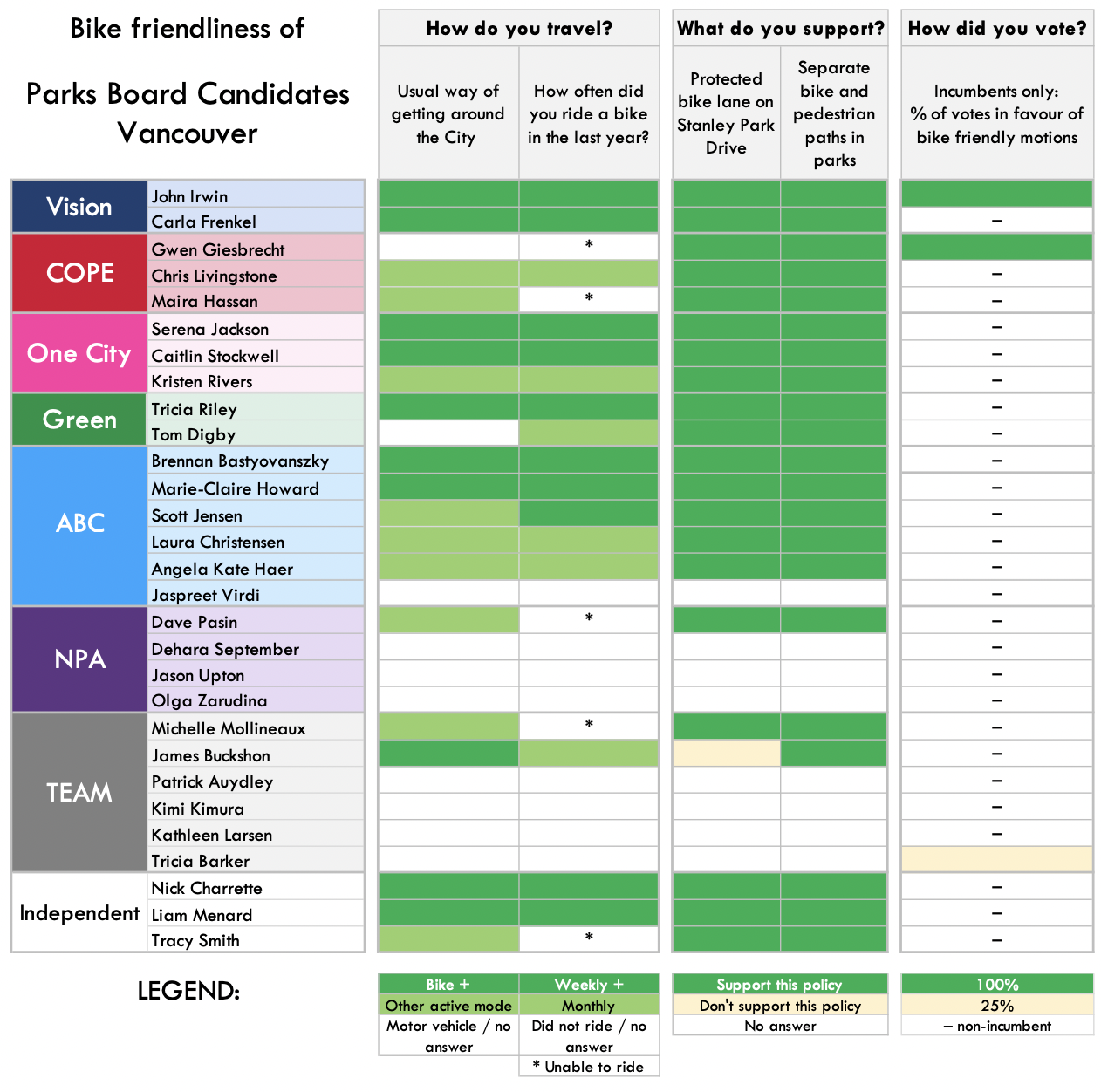
Candidates who have endorsed our Cycling Platform
Iona Bonamis, Christine Boyle, Adriane Carr (PB), Ryan Charmley, David Chin, Ian Cromwell, Tom Digby, Carla Frenkel (PB), Pete Fry, John Irwin (PB), Serena Jackson (PB), Mark Marissen, Liam Menard (PB), Matthew Norris, Kristen Rivers (PB), Dr. Devyani Singh, Stephanie Smith, Caitlin Stockwell (PB), Jean Swanson, Tesicca Truong
Incumbents underlined
*with reservations
Equitable access for all in Stanley Park
July 19, 2024 - Recommendation Letter: Stanley Park Mobility Study
Stanley Park is a jewel in Vancouver and treasured by all. It has been open to visitors since its origin as a park in 1888 by walking and cycling and later by car, bus and other rolling devices. The seawall, the most popular recreational site in the city, circles Stanley Park and beyond. A victim of its own success, it is regularly very congested.
During the pandemic in 2020, the Park Board moved quickly to allow people to bike safely on the roadway in the park to help allow people to distance when biking and walking. The uptake was immediate and massive; during the summer months, there were typically 4,000- 6,000 people1 cycling the roadway every day in the Stanley Park.
In a 2020 survey conducted by the Park Board, the majority of respondents said they enjoyed the changes and would like to see future consideration of dedicated road space for cyclists along with car-free days in Stanley Park. In a 2021 survey, almost three-in-five Vancouverites (59%) thought allowing the 2021 temporary Stanley Park bike lane is a “very good” or “good” idea.
Vancouver's Climate Emergency Action Plan issued an urgent deadline to reduce our carbon pollution by 50% by 2030. Burning fossil fuels in our vehicles is the second most significant source of carbon pollution. We must aggressively reallocate road space to create more equitable active transportation options in our city, just like the reallocation of road space in Stanley Park.
Park Board will vote on a permanent reallocation of park roadway space after staff conduct engagement and research on the idea this year. They must vote a resounding "YES".
Film Credit: Shaun Lang
Resources:
Letter to Park Board commissioners: Reinstallation of temporary bike lane
Cycling Maps
The City of Vancouver and TransLink have created maps of the cycling networks in Vancouver to help all cyclists navigate safely and comfortably on their bikes. These maps are updated regularly to provide current information on cycling and show the comfort levels of each route based on how separated it is from traffic. PDF versions of the maps for Vancouver are available at the links below. Cycling maps for other Metro Vancouver municipalities are available at bikehub.ca/maps.
- City of Vancouver Cycling Map (PDF, Updated 2023)
- City of Vancouver Cycling Resources
- Current Road Closures in Vancouver
- TransLink Vancouver Map (including UBC and YVR) (PDF, Updated Feb 2021)
Reporting Concerns: If you see something that needs to be fixed within the City of Vancouver, call 311 or use the Van311 app to report it.
Cycling 'Hot Spots' in Vancouver
As part of HUB's State of Cycling project, BikeMaps.org produced a series of maps highlighting conflict areas for cyclists across Metro Vancouver. See the map for 'hot spots' in Vancouver (pdf). Please note that these maps show conflicts, but don't account for ridership levels. You can log conflicts/crashes and near misses on BikeMaps.org. Help improve cycling infrastructure and close 'gaps' by getting involved with HUB Cycling's work in your area. See details above for the Vancouver Local Committee. Special thanks to BikeMaps.org for all their help and assistance in producing these maps.
